

Forestry and Agricultural Drone Survey Solutions
Efficiency and Inventory Management with Agricultural and Forestry Drones
Fixed-wing drones are utilized as agronomy and forestry measurement tools in agriculture to survey large plantations to check inventory and ensure the best crop health, achieving the highest yields. These drones can also be deployed for drone farm surveying and drone wildlife survey projects, enabling users to collect accurate environmental and agricultural data over vast areas in minimal time.

Agricultural Drone Surveys for Precision Farming
With the world population consuming more agricultural products for food, fuel, and textiles, precision agriculture has never been more critical. Fixed wing drones are the perfect tool to survey large crop acreage for pests, deficiencies, and damages. Using multi-spectral drone imagery, multiple layers of vegetation indicies can be generated in order to ensure that crop yields are at a maximum. When integrated with agricultural drone survey techniques, our systems help farmers and agronomists detect irrigation issues, nutrient deficiencies, and pest activity earlier. This proactive approach reduces waste, increases yields, and supports sustainable farming practices.
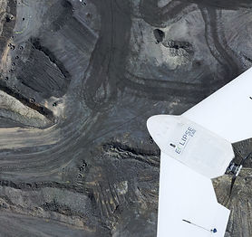
Eclipse 2.0 – Fixed Wing Drone for Forestry and Agriculture Surveys
Eclipse 2.0 is a drone photogrammetry UAV device with RTK/PPK capabilities that captures inventory data in forestry applications. Eclipse 2.0 is the only portable fixed wing drone on the market that has a detachable landing skid. Meaning, this component can be used in even the harshest of weather conditions and environments. Its versatility also makes it suitable for drone for forestry applications, capturing high-resolution data for timber volume estimation, canopy density analysis, and even drone wildlife surveys in forested areas.

Forestry Mapping and Inventory with Drone Technology
Capturing inventory data in forestry applications can certainly be done with UAVs with large area capability. With drone data, stockholders can more accurately know the amount of timber available by using point cloud data to measure trees per acre as well as the volume of trees in an area. By combining UAV capabilities with forestry mapping software, forestry managers can visualize changes over time, plan sustainable harvesting schedules, and even track wildlife habitats without disturbing the environment.
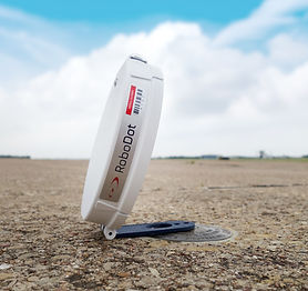
RoboDot – GNSS Receiver for Forestry and Agricultural Mapping
RoboDot is an innovative GNSS receiver. Whether you’re mapping, measuring, or surveying, there’s never been a more simplistic, user-friendly device to help you get the job done. RoboDot can be interfaced with any device as it connects as a Wi-Fi access point and station. Additionally, RoboDot has data sharing and processing capabilities. When paired with agricultural drone survey or drone crop survey missions, RoboDot ensures every image and data point is geo-referenced with pinpoint precision, making post-processing and analysis far more efficient.
To learn more about how our forestry mapping software, drones, and agricultural drone survey equipment can transform your operations, contact us today.


