


Aerial Mapping & Photogrammetry Software for Drone Workflows
Metashape: Advanced Drone Mapping and Photogrammetry Software for Accurate Aerial Surveys
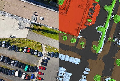
Agisoft Metashape is a cutting-edge software solution, with its engine core driving photogrammetry to its ultimate limits, while the whole system is designed to deliver industry-specific results relying on machine learning techniques for post-processing and analysis tasks.
The software allows to process of images from RGB or multispectral cameras, including multi-camera systems, into dense point clouds, textured polygonal models, georeferenced true orthomosaics, and DSMs/DTMs. Further, post-processing enables to eliminate shadows and texture artifacts from the models, calculate vegetation indices and extract information for farming equipment action maps, automatically classify dense point clouds, etc.
Whether you're capturing imagery via fixed-wing UAVs, multirotor drones, or custom UAS platforms, Metashape is built to handle aerial mapping solutions at scale. From mining sites to agricultural fields, this drone mapping and photogrammetry software ensures accurate 3D reconstruction and geospatial data output for any terrain or use case.

Flexible Deployment Options for High-Volume Aerial Mapping Solutions
Metashape is optimized for multi-core CPUs and multi-GPU systems for fast generation of the results. Distributed processing on a HPC cluster helps to speed up all the calculations for massive data sets even further. These performance features make Metashape one of the most scalable drone mapping and photogrammetry solutions available, ideal for professionals dealing with high-resolution imagery, LiDAR fusion, or multispectral analysis in precision agriculture and land surveying.
Built for Professionals & Academics: UAS Photogrammetry Software for Precision Mapping
Metashape is a perfect tool for aerial imagery processing. The functionality of the program is being constantly developed according to the tasks set by the rapidly emerging UAS industry. As one of the most robust drone mapping and photogrammetry software tools on the market, Metashape is trusted for mission-critical aerial surveys, construction progress monitoring, environmental research, and more.
Metashape has proved to be a professional-level post-processing tool capable of dense point clouds generation and classification for further exceptionally detailed DSMs/DTMs calculations and high-resolution seamless orthomosaics export, not to mention reconstruction of precise polygonal models of large scale objects. It is an indispensable part of GIS workflow starting with a UAV system.
Whether you're a professional surveyor or part of an academic research team, Robota has the right Agisoft Metashape Pro license to support your work. It provides the flexibility and precision needed in modern aerial mapping solutions, particularly when used with high-accuracy GNSS-enabled drones or RTK GPS receivers.
Whether you’re building drone-based photogrammetry workflows for commercial mapping projects or integrating UAS photogrammetry software into classroom research, Robota offers tailored licensing options to meet your needs.
Buy Agisoft Metashape Pro for commercial, professional and educational use.

Features

Dense Point Cloud Generation

Python Scripting

Distance and Area Measurments

DSM/DTM Generation

Generate Contour Lines
Outputs
Testimonials
The RoboDot Touch has completely transformed my surveying workflow with its incredible portability and multi-mode functionality, at an amazing price for professional-grade RTK GPS! -
John Baczkowski
RoboDot Touch is awesome, but the support team is next level!
They helped me get everything set up super fast and actually stuck around to answer all my random questions. Seriously, best service I’ve had in a long time.
Morgan James, NY
The RoboDot is a versatile and reliable RTK GNSS receiver, offering multiple operational modes, robust design, efficient power management, and seamless connectivity. Its integration capabilities with drones like the DJI Mavic M3E and its effectiveness in large site mapping make it an invaluable tool for professionals requiring precise positioning and data collection.
Alejandro Gomez
Frequently Asked Questions
What is the best aerial mapping software?
Agisoft Metashape Pro stands out as the best aerial mapping software, offering robust tools for processing aerial imagery into precise 3D models, orthomosaics, and DSMs/DTMs. Its compatibility with multi-core CPUs, GPUs, and distributed processing ensures efficient handling of large-scale projects, making it a leading choice for aerial mapping solutions.
What is the best photogrammetry software for drones?
Agisoft Metashape Pro is widely regarded as the best photogrammetry software for drones due to its advanced automation, support for various camera types, and high accuracy in generating 3D models and orthomosaics. Its optimization for large datasets and integration with RTK/PPK workflows make it ideal for drone mapping and photogrammetry solutions.
What is aerial mapping used for?
Aerial mapping is used to create detailed maps, orthomosaics, and 3D models of landscapes or sites. It supports land surveying, urban planning, environmental monitoring, agriculture management, and infrastructure development by providing accurate geospatial data through aerial mapping solutions like Agisoft Metashape Pro.
What industries use Metashape Pro for mapping and survey?
Agisoft Metashape Pro is used in industries such as surveying, agriculture, archaeology, cultural heritage preservation, mining, construction, and visual effects. Its ability to generate accurate 3D models and orthomosaics makes it valuable for professionals utilizing UAS photogrammetry software for mapping and analysis.
What is photogrammetry used for?
Photogrammetry is used to create detailed 3D models, maps, and spatial data from images. Applications include topographic mapping, cultural heritage documentation, visual effects production, and precise measurements for surveying, construction, agriculture, and archaeology, leveraging drone mapping and photogrammetry software like Agisoft Metashape Pro.
What equipment is needed for photogrammetry?
Photogrammetry with Agisoft Metashape Pro requires a drone or camera (RGB or multispectral, 5+ megapixels), a computer with a multi-core CPU, sufficient RAM (32+ GB recommended), and a high-end GPU for faster processing. Optional equipment includes RTK/PPK-enabled drones or ground control points (GCPs) for enhanced accuracy in drone mapping and photogrammetry solutions.
Can any drone be used for photogrammetry?
Not all drones are suitable for photogrammetry. Drones used for photogrammetric surveys typically need a stable flight platform, a quality camera, and precise GPS functionality to ensure accurate and reliable data. Agisoft Metashape Pro supports imagery from a wide range of drones, as long as they capture overlapping images with sufficient clarity and consistency. This makes the software versatile and compatible with many UAV platforms for aerial mapping solutions.
How accurate is drone photogrammetry?
Drone photogrammetry with Agisoft Metashape Pro achieves high accuracy, often reaching up to 3 cm for aerial imagery and 1 mm for close-range photography. The software’s precise image alignment and integration with RTK/PPK workflows ensure reliable results for professional mapping and surveying applications using UAS photogrammetry software.
Can Agisoft Metashape Pro be used for large site mapping?
Yes, Agisoft Metashape Pro is highly effective for large site mapping. It is optimized for processing massive datasets using multi-core CPUs, multi-GPU systems, and distributed processing on high-performance computing clusters, enabling fast and accurate generation of 3D models and orthomosaics for extensive areas, making it a top choice for drone mapping and photogrammetry software.
What are the main features of Agisoft Metashape Pro?
Agisoft Metashape Pro offers advanced features including automated image processing, support for RGB and multispectral cameras, and generation of dense point clouds, textured polygonal models, and georeferenced orthomosaics. It supports multi-core CPUs and GPUs for fast processing, offline operation, and distributed processing for large datasets. Additional capabilities include shadow and texture artifact removal, vegetation index calculation, and compatibility with drone mapping and photogrammetry solutions.
What is Agisoft Metashape Pro used for?
Agisoft Metashape Pro is a professional photogrammetry software used to process digital images and generate high-quality 3D spatial data. It transforms images from drones, cameras, or multi-camera systems into dense point clouds, textured 3D models, orthomosaics, and digital surface models (DSMs) or digital terrain models (DTMs), making it ideal for aerial mapping solutions in various industries.