


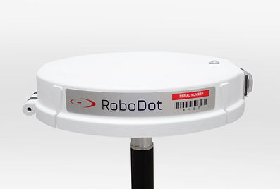
RoboDot RTK Receiver: Affordable, Precise & Built for Real-World Surveying
Fast & Accurate GNSS Referencing for Surveying and Mapping
Please see the RoboDot Touch - our active solution.
RoboDot RTK GPS receiver makes high-precision measurement accessible with a simple, affordable, and field-proven design. Whether you're planning to buy a GNSS receiver for RTK GPS surveying, drone mapping, or real-time navigation, RoboDot delivers. With its flexible user interface, rugged durability, and quick deployment features, it’s the RTK receiver built for real-world fieldwork across diverse applications.
Multi-Use Flexibility: RTK Base Station, Rover, and Static Logger in One
Use RoboDot as an RTK GPS base station to send real-time corrections via WiFi using NTRIP, UDP, or LoRa Radio. It's equally powerful in RTK rover mode, receiving corrections through NTRIP or its built-in long-range LoRa radio. For post-processing, RoboDot supports high-quality static data logging compatible with PPP workflows like OPUS, making it a favorite among professionals who use RTK GPS for surveying, drone GCP placement, or boundary mapping.

Rugged & Field-Tested: A Durable RTK Receiver for All Terrains
This compact yet powerful RTK receiver is engineered to survive tough job sites. Backed by a 12-month manufacturer warranty, RoboDot features an IP67-rated enclosure that protects against dust and water intrusion up to 1 meter. Whether you're working in the field, forest, or farm, this GNSS receiver is rugged enough for harsh surveying conditions.

All-Day Power: GNSS Receiver with 10+ Hour Battery Life
Designed with efficiency in mind, RoboDot offers over 10 hours of battery life per charge, ensuring full-shift performance. For extended use cases, such as static logging or multi-location surveys, simply connect an external USB power bank for uninterrupted operation. Surveyors looking to buy a GNSS receiver that balances power and portability will appreciate RoboDot’s all-day endurance.
Smart Design for Fast Setup: Ideal for GCPs and Drone Surveying
RoboDot’s distinctive circular shape is more than aesthetic, it’s a functional advantage. The integrated locating tool and visual centering marks reduce setup time dramatically, especially when working with nails, painted GCPs, or known survey markers. Whether mounted on a tripod or placed directly on the ground, it’s ideal for RTK GPS surveying and acts as a reference-scale GCP in drone photogrammetry thanks to its standard .5ft x .1ft dimensions.

Seamless Connectivity: Compatible with NTRIP Rovers and Drone Controllers
Connectivity is where RoboDot truly shines. Acting as both a WiFi access point and station, it easily syncs with any rover that supports NTRIP. Control it via any browser, iPhone, Android, Mac, PC, or even DJI drone controllers. Optional 915 MHz LoRa radios provide stable long-range base-to-rover communication, a must-have for pros who rely on RTK GPS for surveying in the field. If you're planning to buy a GNSS receiver that works with your existing ecosystem, RoboDot is a plug-and-play performer.

Features

GNSS Frequencies
L1C/A, L2C, L1OF, L2OF, E1B/C, E5b, B1I, B2I

Logging Memory
16Gb

User Interface
Web App

Updates
Wireless
Wireless Communication
Optional - 915 MHz Lora

Communication Port
USB Type C
Wireless Communication
2.4 GHz WIFI AP and Station

GNSS
PPK Precision

External Trigger
Version 2 - Input Trigger Pin, 3v TTL

Operating Temp
-10 to 65 ºC

Size
.5 x .1 ft (15.24 x 3.04 cm)

GNSS
RTK Precision

Weight
12 oz (340 gram)

Ingress protection
IP67
Run Time
10+ hrs

Operating Modes
Base Station, Rover, Logger
GNSS Constellations
GPS GLONASS Galileo BeiDou

Charging
USB Type C 5v, 1A
Outputs

Formatted Position Data
Cloud Processed Option SPC,UTM,XYZ

Correction Data
RTCM3 via USB, 3v TTL, or NTRIP

Precise Time Pulse
Version 2 - 3v TTL Output Pin
Observation Data
RINEX .obs, .nav Files

Rover Position Data
Shot List File .sht (csv)

PPK Position Data
Coordinates File .csv

Position Data
NMEA over USB or 3v TTL
Testimonials
The RoboDot Touch has completely transformed my surveying workflow with its incredible portability and multi-mode functionality, at an amazing price for professional-grade RTK GPS! -
John Baczkowski
RoboDot Touch is awesome, but the support team is next level!
They helped me get everything set up super fast and actually stuck around to answer all my random questions. Seriously, best service I’ve had in a long time.
Morgan James, NY
The RoboDot is a versatile and reliable RTK GNSS receiver, offering multiple operational modes, robust design, efficient power management, and seamless connectivity. Its integration capabilities with drones like the DJI Mavic M3E and its effectiveness in large site mapping make it an invaluable tool for professionals requiring precise positioning and data collection.
Alejandro Gomez
Frequently Asked Questions
How to use RTK in surveying step by step?
To use RTK in surveying:
1. Use an RTK base station or an NTRIP service as the correction source
2. Power on your RTK rover (like Robodot)
3. Connect the rover to the correction source
4. Begin collecting points using your preferred survey software
Robodot simplifies this process by offering a plug-and-play RTK GPS solution for surveying, making setup fast and efficient.
What is the range of RTK GPS?
The range of RTK GPS depends on the communication method. With Robodot, a 915 MHz radio link provides up to 1 km of range (line of sight) between two units. WiFi, used for direct device interface, is limited to about 400 ft. For longer distances, internet-based corrections (such as NTRIP) can support baseline lengths up to 50 km, though accuracy may degrade with increased distance. If you're looking for a GNSS receiver offering flexible connectivity options and reliable performance in diverse environments, Robodot is a solid choice.
How accurate is the RTK GPS?
RTK GPS technology delivers up to 1 cm horizontal and 2 cm vertical accuracy under optimal conditions. The Robodot system from Robota is built for dependable field performance, making it a reliable choice for professionals who need accurate, compact, and durable RTK GPS for surveying.
Is RTK better than GPS?
Yes, when precision matters, RTK is significantly more accurate than standard GPS. While standard GPS typically provides accuracy within a few meters, RTK can achieve 1–2 centimeter precision using correction signals. Robodot is a trusted RTK receiver that enables professionals to reach survey-grade accuracy with ease and reliability.
What is RTK surveying?
RTK surveying involves using GNSS signals with real-time correction data to achieve high-accuracy land measurements. It eliminates the need for extensive ground control points and speeds up fieldwork. Robodot enables precise RTK surveying through a user-friendly setup that pairs easily with your drone, rover, or field controller.
What are the different types of GNSS receivers?
GNSS receivers vary by precision level and use case. Basic receivers offer meter-level accuracy for consumer use, while high-end models like RTK and PPK receivers provide centimeter-level precision for professional applications. For users seeking consistent performance in tough environments, Robota’s Robodot is a field-tested, professional-grade RTK GPS for surveying.
What does a GNSS receiver do?
A GNSS receiver captures satellite signals from multiple global navigation systems, like GPS, GLONASS, Galileo, and BeiDou to determine highly accurate position data. If you're looking to enhance location accuracy in your workflow, Robodot is a reliable option for those looking to buy a GNSS receiver built for field durability and seamless integration.
What is an RTK receiver?
An RTK receiver is a high-precision GPS device that uses real-time correction data from a base station to deliver centimeter-level accuracy. The Robodot by Robota is a rugged, plug-and-play RTK receiver designed for precision applications like drone mapping, construction, and agriculture.