
How to Map a Site Without an Initial Survey Point
- Antonio Liska

- Apr 27, 2021
- 2 min read
Updated: Sep 22, 2025
It's a common scenario when mapping with drones, you show up to a site, and no survey markers or coordinates have been provided. If you need to get the job done right away, you can use your RoboDot to map the site without an initial point for your RTK base station. Here's how.
For future reference, you may elect to mark the point that you will set the RoboDot over. You can mark a point with our GCP stencil or a nail, for example. Set the RoboDot over the point and turn it on.

Connect the drone (Rover) to the RoboDot's NTRIP server as if you were connecting to a VRS. When the mission is flown, the images will be located precisely but not accurately. Their coordinates will be offset by an arbitrary amount based on the RoboDots "standalone" position.
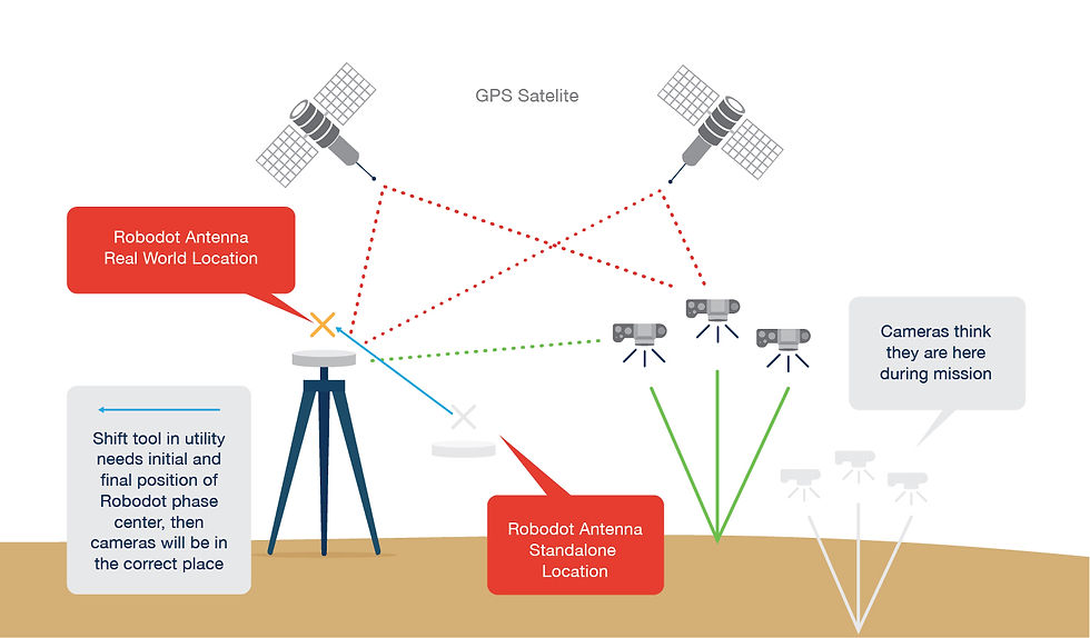
In order to make the image locations accurate, the real-world position of the RoboDot needs to be determined. This can be done at a later time by surveying the GCP where RoboDot operated or by submitting the recorded RINEX log files from the base station to a PPP service such as OPUS.
Using the RoboDot utility, it's easy to shift the locations stored in the images to their real-world location. Start by selecting the images from the mission, entering the real world position and standalone position (obtainable from the RoboDot's Rinex file), and starting the shifting process.
The RoboDot GNSS reference station makes it easy to produce highly accurate maps, reach out via our contact form if you have questions about how RoboDot applies to your operation.


Comments