

Drone Mapping for Environmental Protection and Monitoring
UAV solutions with hyperspectral drone survey equipment monitor environmental changes, detecting pollution and vegetation stress. These commercial drone solutions archive data for compliance, supporting conservation with precise records.
Our drone photogrammetry for environment protection consists of portable fixed-wing drones to empower stakeholders to make informed decisions during disasters including fires, eruptions, earthquakes, tornados, and hurricanes. Photogrammetry drones are also used in reporting waste in landfills and coastlines to ensure protective environment precautions are being taken.
These environmental monitoring systems also support pollution tracking, habitat mapping, and shoreline monitoring. Whether in remote forests, coastal zones, or urban areas, our environmental drone mapping tools provide consistent, high-resolution insights that help decision makers respond quickly and responsibly.

Drone Disaster Assessment for Relief Operations
After a natural disaster strikes, there are many unknowns, what is the extent of the damage? Could there be survivors? Whose property is in danger? Many of these questions can be answered by drone data to provide a top-down view of the stricken area, allowing leaders to make informed decisions. Our UAV environmental monitoring solutions deliver real-time aerial imagery that helps emergency responders prioritize rescue operations, assess infrastructure damage, and allocate resources effectively. This rapid drone disaster assessment reduces response time and improves safety for both communities and responders.
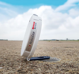
RoboDot: Smart GNSS Reference for Environmental Drone Mapping Tools
Whether you’re a beginner or a veteran when it comes to surveying, RoboDot will greatly impact your decisions when it comes to taking protective environment precautions. RoboDot is a comprehensible GNSS reference station that’s easy to use and operates as a smart ground control point. Additionally, RoboDot possesses connectivity features on any browser-enabled device for your convenience.
When used in conjunction with environmental mapping tools, RoboDot ensures that survey-grade coordinates are accurate, even in challenging terrain. This is critical for environmental drone mapping applications where precise location data is necessary for compliance reporting and habitat change detection.

Firefighting and Environmental Damage Monitoring
Aerial imagery is extremely useful in decision making, monitoring, and reporting in large wildfires. Aerial photogrammetry drone data gives a bird’s-eye view of the problem, allowing stakeholders to better understand the fire perimeter and progress. Even once the fire is out, area burnt, and damages can be recorded in orthomosaics.
Beyond active fire monitoring, UAV environmental monitoring systems help assess post-fire soil erosion risks, vegetation loss, and habitat damage. Using environmental monitoring devices, authorities can plan effective restoration and prevention strategies.
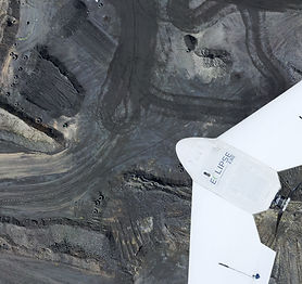
Eclipse 2.0: Long-Endurance Photogrammetry UAV for Environmental Surveys
Achieve professional photogrammetric mapping with Eclipse 2.0. Eclipse 2.0 is a photogrammetry UAV that can manage through harsh weather conditions and fly for up to six and a half hours at once over significant territories. With its advanced RTK/PPK capabilities, it’s now easier to map your area to begin the land surveying process with Eclipse 2.0. With its endurance and RTK/PPK precision, Eclipse 2.0 is ideal for environmental drone mapping over large territories, enabling high-accuracy orthomosaics and terrain models for environmental impact studies, wildlife monitoring, and land management.

Waste Management with Drone Mapping Tools
Waste management requires constant reporting and measurements of quantities, it is also a dangerous area for a surveyor to put himself into. With drone technology, there is no reason for traditional surveys of landfills to take place. Using a drone is not only much safer but more accurate than stakeouts on foot. Environmental monitoring devices attached to drones can capture volumetric measurements of waste piles, detect illegal dumping sites, and monitor landfill boundaries. These environmental mapping tools enhance compliance reporting and support safer, more efficient waste management practices.
Contact Us today for Drone Environmental Monitoring and Mapping Solutions.
Related Products


Frequently asked questions
Frequently Asked Questions
How do drones assist in wildfire monitoring and firefighting?
Drones provide real-time thermal imaging to locate hotspots and track fire movement. In a drone disaster assessment, they help firefighting teams create response maps, assess danger zones, and monitor post-fire recovery, ensuring resources are used effectively.
What types of data can drones collect for environmental monitoring?
Drones collect a wide range of data, including high-resolution images, thermal readings, LiDAR scans, and multispectral imagery. This makes drone environmental monitoring essential for tracking land use, plant health, water resources, and atmospheric conditions.
What are the benefits of using drones in disaster relief and emergency response?
In drones for disaster response and relief operations, drones quickly provide situational awareness, helping teams assess infrastructure damage, locate people in need, and prioritize recovery efforts. They reduce response time and improve coordination in critical moments.
How are drones used for environmental protection?
Drones enhance drone environmental monitoring by identifying deforestation, mapping protected zones, and tracking climate-related changes. These insights help government and NGOs implement effective conservation strategies based on accurate, real-time data.
How can drones be used to protect the environment?
By capturing up-to-date aerial data, drones support early detection of environmental risks like illegal logging, pollution, or land encroachment. Drones in environmental management are used to enforce environmental laws and ensure sustainability goals are met.
How are drones being used in nature conservation?
Drones for wildlife conservation help monitor animal populations, detect poaching activity, and observe species without disturbing them. With aerial surveys and thermal imaging, conservationists can cover vast terrain efficiently and safely.
What is the primary advantage of using UAVs for environmental monitoring?
UAV environmental monitoring offers unmatched spatial accuracy and frequency. Unlike satellites, drones can fly lower and collect more detailed data, perfect for mapping microhabitats, analyzing tree canopies, or identifying early signs of stress in crops and forests.
How does drone technology contribute to environmental analysis?
Drones equipped with multispectral sensors and GNSS receivers can track environmental changes over time. In a drone disaster assessment, they help identify damaged ecosystems and calculate areas affected by events like wildfires or oil spills.
What is the primary benefit of drones in environmental monitoring?
The biggest advantage is accessibility. Drones in environmental management enable scientists and land managers to monitor remote or hazardous areas quickly without risking human safety. This helps in timely detection of ecological threats and better conservation planning.
Can drones be used for environmental monitoring?
Yes, drones are ideal for UAV environmental monitoring. They can collect data on vegetation health, soil erosion, water levels, and atmospheric conditions. Unlike traditional methods, drones offer fast, cost-effective, and repeatable data collection over large or remote areas.
How could drones be used to help the environment?
Drones aid the environment by tracking deforestation, surveying wetlands, and monitoring land degradation. A drone environmental monitoring mission can capture high-resolution images and data that help researchers and policy makers respond proactively to ecological changes.
How are drones used in disaster response?
Drones for disaster response and relief operations are deployed to assess damage, locate survivors, and deliver real-time visuals to emergency teams. Their ability to fly over inaccessible areas makes them invaluable during floods, wildfires, and earthquakes, streamlining decision-making and speeding up rescue missions.